


 Syntax
| Visual Basic (Declaration) | |
|---|---|
Public Property DynamicLayerInfos As DynamicLayerInfoCollection | |
| C# | |
|---|---|
public DynamicLayerInfoCollection DynamicLayerInfos {get; set;} | |
Remarks
Dynamic Layers allow the execution of various ArcGIS Server requests from a client application. An in-depth discussion about Dynamic Layers is in the ArcGISDynamicMapServiceLayer Class documentation. The client side requests that can be issued to ArcGIS Server include the ability to:
- Change the rendering of an existing ArcGISDynamicMapServiceLayer. See the code examples in the ArcGISDynamicMapServiceLayer.LayerDrawingOptions Property, the ArcGISDynamicMapServiceLayer.CreateDynamicLayerInfosFromLayerInfos Method, and the LayerDrawingOptionsCollection Class.
- Create a layer on-the-fly for the Workspace Types of: Database, Shapefile, FileGDB, and Raster. See the code examples in the ArcGISDynamicMapServiceLayer.DynamicLayerInfos Property and the DynamicLayerInfoCollection Class.
- Perform table joins.
- Query for specific records. See the code example for the QueryDataSource Class.
- Identify features. See the code example in this document.
- Return raster images.
Dynamic Layers are new in ArcGIS Server v10.1 and require the ArcGIS Runtime SDK 1.0 for WPF and higher.
Example
How to use:
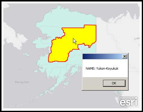
After the Layers load in the Map, click on a 'County' to obtain Identify information for the Dynamic Layer. The Dynamic Layer that is generated is based upon the 'Workspace Type' of 'Database' using a LayerMapSource for the LayerDataSource. The point is to show how the ESRI.ArcGIS.Client.Tasks.IdentifyParameters.DynamicLayerInfos Property can be used to obtain Identify information about a Dynamic Layer.The XAML code in this example is used in conjunction with the code-behind (C# or VB.NET) to demonstrate the functionality.
The following screen shot corresponds to the code example in this page.
| XAML |  Copy Code Copy Code |
|---|---|
<Grid x:Name="LayoutRoot"> <!-- Add a Map Control. Zoom to Alaska. Note the use of the MouseClick and Loaded Events are used with code-behind logic. --> <esri:Map Background="White" HorizontalAlignment="Left" Margin="0,204,0,0" Name="Map1" VerticalAlignment="Top" Height="350" Width="500" Extent="-20686124,6677550,-13657836,11597352" MouseClick="Map1_MouseClick" Loaded="Map1_Loaded"> <!-- Add a backdrop ArcGISTiledMapServiceLayer. --> <esri:ArcGISTiledMapServiceLayer ID="myArcGISTiledMapServiceLayer" Url="http://services.arcgisonline.com/ArcGIS/rest/services/Canvas/World_Light_Gray_Base/MapServer" /> <!-- Add a Dynamic Layer based on an existing ArcMap and ArcGIS Server map service ArcGISDynamicMapServiceLayer sub-layer (specifically the 'Counties' or [3] sub-layer). A Dynamic Layer is a web request where the client application issues an ArcGIS Server command to generate an on-the-fly layer for display in the Map Control. Note: the DisableClientCaching is set to true so that what ever is returned from the server will be displayed. In order to create the Dynamic Layer the following are occuring: (1) create a DynamicLayerInfo object and set the .ID and .Source Properties (2) add that DynamicLayerInfo object to the ArcGISDynamicMapServiceLayer .DynamicLayerInfos collection Note: It is not mandatory to set the ArcGISDynamicMapServiceLayer.LayerDrawingOptions if your Dynamic Layer is based upon a LayerMapSource. The Dynamic Layer that is getting created automatically uses the existing Symbology of the ArcGISDynamicMapServiceLayer sub-layer, unless you override it. --> <esri:ArcGISDynamicMapServiceLayer ID="myArcGISDynamicMapServiceLayer" Opacity="0.2" DisableClientCaching="True" Url="http://sampleserver6.arcgisonline.com/arcgis/rest/services/USA/MapServer" > <esri:ArcGISDynamicMapServiceLayer.DynamicLayerInfos> <esri:DynamicLayerInfoCollection> <esri:DynamicLayerInfo ID="99"> <esri:DynamicLayerInfo.Source> <esri:LayerMapSource MapLayerID="3" /> </esri:DynamicLayerInfo.Source> </esri:DynamicLayerInfo> </esri:DynamicLayerInfoCollection> </esri:ArcGISDynamicMapServiceLayer.DynamicLayerInfos> </esri:ArcGISDynamicMapServiceLayer> <!-- Add an empty GraphicsLayer to showcase where the user clicks on the Map for the feature being Identified. --> <esri:GraphicsLayer ID="myGraphicsLayer" /> </esri:Map> <!-- Provide the instructions on how to use the sample code. --> <TextBlock Height="147" HorizontalAlignment="Left" Name="TextBlock1" VerticalAlignment="Top" Width="788" TextWrapping="Wrap" Text="After the Layers load in the Map, click on a 'County' to obtain Identify information for the Dynamic Layer. The Dynamic Layer that is generated is based upon the 'Workspace Type' of 'Database' using a LayerMapSource for the LayerDataSource. The point is to show how the ESRI.ArcGIS.Client.Tasks.IdentifyParameters.DynamicLayerInfos Property can be used to obtain Identify information about a Dynamic Layer."/> </Grid> | |
| C# | Copy Code |
|---|---|
// Create some Member (i.e Global in scope) variables for the ArGISDynamicMapServiceLayer, IdentifyParameters, // and IdentifyTask objects. private ESRI.ArcGIS.Client.ArcGISDynamicMapServiceLayer _MyArcGISDynamicMapServiceLayer; private ESRI.ArcGIS.Client.Tasks.IdentifyParameters _MyIdentifyParameters = new ESRI.ArcGIS.Client.Tasks.IdentifyParameters(); private ESRI.ArcGIS.Client.Tasks.IdentifyTask _MyIdentifyTask = new ESRI.ArcGIS.Client.Tasks.IdentifyTask("http://sampleserver6.arcgisonline.com/arcgis/rest/services/USA/MapServer"); private void Map1_Loaded(object sender, System.Windows.RoutedEventArgs e) { // When the Map loads all of its Layers, get the ArcGISDynamicMapServiceLayer defined in XAML. Allow // DisableClientCaching for the IdentifyTask request. _MyArcGISDynamicMapServiceLayer = Map1.Layers["myArcGISDynamicMapServiceLayer"] as ESRI.ArcGIS.Client.ArcGISDynamicMapServiceLayer; _MyIdentifyTask.DisableClientCaching = true; // Create some Event Handlers to account for when the IdentifyTask completes. _MyIdentifyTask.ExecuteCompleted += identify_ExecuteCompleted; _MyIdentifyTask.Failed += identify_Failed; } private void Map1_MouseClick(object sender, ESRI.ArcGIS.Client.Map.MouseEventArgs e) { // Set all of the Parameters on the IdentifyTask request. _MyIdentifyParameters.Geometry = e.MapPoint; // Where the user clicked on the Map. _MyIdentifyParameters.ReturnGeometry = true; // Get the spatial geometry information. _MyIdentifyParameters.SpatialReference = Map1.SpatialReference; // Get the SpatialReference information. _MyIdentifyParameters.MapExtent = Map1.Extent; // Get the Extent of the Map. _MyIdentifyParameters.DynamicLayerInfos = _MyArcGISDynamicMapServiceLayer.DynamicLayerInfos; // Get the Dynamic Layer information. _MyIdentifyParameters.Height = Convert.ToInt32(Map1.Height); // Required parameter setting for services on AGS 10.1 and higher. _MyIdentifyParameters.Width = Convert.ToInt32(Map1.Width); // Required parameter setting for services on AGS 10.1 and higher. // Catch for the user clicking again on the Map before a first Identify results are processed. if (_MyIdentifyTask.IsBusy) { _MyIdentifyTask.CancelAsync(); } // Execute the Asynchronous request to Identify the Dynamic Layer Features where the user clicked on the Map. _MyIdentifyTask.ExecuteAsync(_MyIdentifyParameters); } private void identify_Failed(object sender, ESRI.ArcGIS.Client.Tasks.TaskFailedEventArgs e) { // "Houston, we have a problem!" MessageBox.Show(e.Error.Message); } private void identify_ExecuteCompleted(object sender, ESRI.ArcGIS.Client.Tasks.IdentifyEventArgs e) { // Get the Graphics Layer defined in XAML and clear out any previous Graphics. ESRI.ArcGIS.Client.GraphicsLayer myGraphicsLayer = (ESRI.ArcGIS.Client.GraphicsLayer)(Map1.Layers["myGraphicsLayer"]); myGraphicsLayer.ClearGraphics(); // Create a StringBuilder object to hold Identify information that will be relayed to the user. Text.StringBuilder myStringBuilder = new Text.StringBuilder(); // Get the IdentifyResults. System.Collections.Generic.List<ESRI.ArcGIS.Client.Tasks.IdentifyResult> myListOfIdentifyResult = e.IdentifyResults; if (myListOfIdentifyResult.Count == 1) { // We are only interested in the first result of the Identify. // Create a SimpleFillSymbol using the solid Yellow brush and set the Border to be Red with a thickness // of 2. This will be used to accentuate the display of the Feature the user clicked on. ESRI.ArcGIS.Client.Symbols.SimpleFillSymbol newSimpleFillSymbol = new ESRI.ArcGIS.Client.Symbols.SimpleFillSymbol(); newSimpleFillSymbol.Fill = new System.Windows.Media.SolidColorBrush(Colors.Yellow); newSimpleFillSymbol.BorderBrush = new System.Windows.Media.SolidColorBrush(Colors.Red); newSimpleFillSymbol.BorderThickness = 2; // Get the Feature (a Graphic) that is returned from the Identify operation, set it's Symbol, and // add it to the GraphicsLayer. This will cause an automatic redraw of the Map. ESRI.ArcGIS.Client.Graphic myGraphic = myListOfIdentifyResult[0].Feature; myGraphic.Symbol = newSimpleFillSymbol; myGraphicsLayer.Graphics.Add(myGraphic); // Get the DisplayFieldName and its Value of the first result. string myDisplayFieldName = myListOfIdentifyResult[0].DisplayFieldName; string myValue = myListOfIdentifyResult[0].Value.ToString(); // Add the Identify information into the StringBuilder and display it in a MessageBox. myStringBuilder.Append(myDisplayFieldName + ": " + myValue); MessageBox.Show(myStringBuilder.ToString()); } else { // Let the user know they did not click on a Feature. MessageBox.Show("No Features Found!"); } } | |
| VB.NET | Copy Code |
|---|---|
' Create some Member (i.e Global in scope) variables for the ArGISDynamicMapServiceLayer, IdentifyParameters, ' and IdentifyTask objects. Private _MyArcGISDynamicMapServiceLayer As ESRI.ArcGIS.Client.ArcGISDynamicMapServiceLayer Private _MyIdentifyParameters As New ESRI.ArcGIS.Client.Tasks.IdentifyParameters() Private _MyIdentifyTask As New ESRI.ArcGIS.Client.Tasks.IdentifyTask("http://sampleserver6.arcgisonline.com/arcgis/rest/services/USA/MapServer") Private Sub Map1_Loaded(sender As System.Object, e As System.Windows.RoutedEventArgs) ' When the Map loads all of its Layers, get the ArcGISDynamicMapServiceLayer defined in XAML. Allow ' DisableClientCaching for the IdentifyTask request. _MyArcGISDynamicMapServiceLayer = TryCast(Map1.Layers("myArcGISDynamicMapServiceLayer"), ESRI.ArcGIS.Client.ArcGISDynamicMapServiceLayer) _MyIdentifyTask.DisableClientCaching = True ' Create some Event Handlers to account for when the IdentifyTask completes. AddHandler _MyIdentifyTask.ExecuteCompleted, AddressOf identify_ExecuteCompleted AddHandler _MyIdentifyTask.Failed, AddressOf identify_Failed End Sub Private Sub Map1_MouseClick(sender As System.Object, e As ESRI.ArcGIS.Client.Map.MouseEventArgs) ' Set all of the Parameters on the IdentifyTask request. _MyIdentifyParameters.Geometry = e.MapPoint ' Where the user clicked on the Map. _MyIdentifyParameters.ReturnGeometry = True ' Get the spatial geometry information. _MyIdentifyParameters.SpatialReference = Map1.SpatialReference ' Get the SpatialReference information. _MyIdentifyParameters.MapExtent = Map1.Extent ' Get the Extent of the Map. _MyIdentifyParameters.DynamicLayerInfos = _MyArcGISDynamicMapServiceLayer.DynamicLayerInfos ' Get the Dynamic Layer information. _MyIdentifyParameters.Height = CInt(Map1.Height) 'Required parameter setting for services on AGS 10.1 and higher. _MyIdentifyParameters.Width = CInt(Map1.Width) 'Required parameter setting for services on AGS 10.1 and higher. ' Catch for the user clicking again on the Map before a first Identify results are processed. If _MyIdentifyTask.IsBusy Then _MyIdentifyTask.CancelAsync() End If ' Execute the Asynchronous request to Identify the Dynamic Layer Features where the user clicked on the Map. _MyIdentifyTask.ExecuteAsync(_MyIdentifyParameters) End Sub Private Sub identify_Failed(ByVal sender As Object, ByVal e As ESRI.ArcGIS.Client.Tasks.TaskFailedEventArgs) ' "Houston, we have a problem!" MessageBox.Show(e.Error.Message) End Sub Private Sub identify_ExecuteCompleted(ByVal sender As Object, ByVal e As ESRI.ArcGIS.Client.Tasks.IdentifyEventArgs) ' Get the Graphics Layer defined in XAML and clear out any previous Graphics. Dim myGraphicsLayer As ESRI.ArcGIS.Client.GraphicsLayer = CType(Map1.Layers("myGraphicsLayer"), ESRI.ArcGIS.Client.GraphicsLayer) myGraphicsLayer.ClearGraphics() ' Create a StringBuilder object to hold Identify information that will be relayed to the user. Dim myStringBuilder As New Text.StringBuilder ' Get the IdentifyResults. Dim myListOfIdentifyResult As System.Collections.Generic.List(Of ESRI.ArcGIS.Client.Tasks.IdentifyResult) = e.IdentifyResults If myListOfIdentifyResult.Count = 1 Then ' We are only interested in the first result of the Identify. ' Create a SimpleFillSymbol using the solid Yellow brush and set the Border to be Red with a thickness ' of 2. This will be used to accentuate the display of the Feature the user clicked on. Dim newSimpleFillSymbol As New ESRI.ArcGIS.Client.Symbols.SimpleFillSymbol newSimpleFillSymbol.Fill = New System.Windows.Media.SolidColorBrush(Colors.Yellow) newSimpleFillSymbol.BorderBrush = New System.Windows.Media.SolidColorBrush(Colors.Red) newSimpleFillSymbol.BorderThickness = 2 ' Get the Feature (a Graphic) that is returned from the Identify operation, set it's Symbol, and ' add it to the GraphicsLayer. This will cause an automatic redraw of the Map. Dim myGraphic As ESRI.ArcGIS.Client.Graphic = myListOfIdentifyResult(0).Feature myGraphic.Symbol = newSimpleFillSymbol myGraphicsLayer.Graphics.Add(myGraphic) ' Get the DisplayFieldName and its Value of the first result. Dim myDisplayFieldName As String = myListOfIdentifyResult(0).DisplayFieldName Dim myValue As String = myListOfIdentifyResult(0).Value.ToString ' Add the Identify information into the StringBuilder and display it in a MessageBox. myStringBuilder.Append(myDisplayFieldName + ": " + myValue) MessageBox.Show(myStringBuilder.ToString) Else ' Let the user know they did not click on a Feature. MessageBox.Show("No Features Found!") End If End Sub | |
Requirements
Target Platforms: Windows XP Professional, Windows Server 2003 family, Windows Vista, Windows Server 2008 family, Windows 7, Windows 8