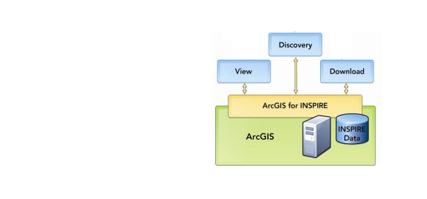
Erfahren Sie, wie Sie mit INSPIRE konforme räumliche Dateninfrastrukturen mit ArcGIS for INSPIRE implementieren können
Weitere Informationen...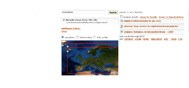
INSPIRE-Dienste und standardbasierte Services freigeben, finden und verwenden
Weitere Informationen ...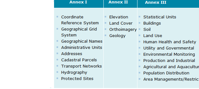
Gleichen Sie mit der ArcGIS for INSPIRE-Geodatabase-Vorlage Ihre Daten an
Weitere Informationen ...The ArcGIS Online team wants you to remind you of the terms of use for geocoding. Geocoding can be broken into two functions: Geosearch and Geocoding. Geosearch Services – “Geosearch” is about locating a feature or point of interest and … Continue reading
ArcGIS for Maritime: Charting supports and maintains a large percentage of checks listed in the International Hydrographic Organization (IHO) publication S-58 Recommended ENC Validation Checks, edition 4.2. Using the ArcGIS Data Reviewer for Desktop extension, checks can easily be configured … Continue reading
Have you ever played around with the Brightness, Contrast, Transparency, and Gamma sliders in the Image Analysis window? Now have you used the slider and then wanted to return back to zero? Sure you can try to move the slider … Continue reading
by Robert Kimball and Paul Reig, Aqueduct Project, World Resources Institute Water is not just an environmental issue – it has the power to create risks and opportunities that can impact companies, investors, and entire economies. Further proof of this … Continue reading
By Damien Demaj Late last year I introduced ArcGIS users to sports analytics, an emerging and exciting field within the GIS industry. Using ArcGIS for sports analytics can be read here. Recently I expanded the work by using a number … Continue reading