Another important part of building a valuable GIS is data compilation and the editing of geographic data. If we look at the various information models created for the communities on the ArcGIS Resouce Center, we see a distinct pattern of how they are built and how a GIS is put together.
The communities model information in a geodatabase. All of the geographic data is stored there and it is the geodatabase that allows the communities to build the foundational layers such as parcel and utility layers, complete with associated rules and behavior, which they need for each specific industry.

Since each community has its own types of data and workflows for gathering and editing that data, so too does each community have specific tools and advanced data compilation workflows. These workflows are built around the particular types of information an industry is trying to collect and the business rules associated with that type of data.
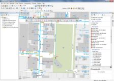
If we look at the Water Utilities community as an example, we see that it has a preconfigured template available for download called the Infrastructure Network Editing Template. Within that template is an editing map with a number of editing toolbars that have built-in workflows set up specifically for managing water, sewer and storm water utility data. These Infrastructure Editing toolbars contain a series of custom editing and reporting tools that improve the editing experience for ArcGIS users working with infrastructure data.
A good place to get started learning about data compilation and editing workflows is to download a template from a community page appropriate to your own type of work and see how the toolbars interact with the sample data that is provided. This will give you an idea of the types of data, tools and workflows you will want when building your GIS.