Description
Used to render features according to the value in a specified field. Based on this field, a value map can be created to classify data.
Diagram
Overview
 |
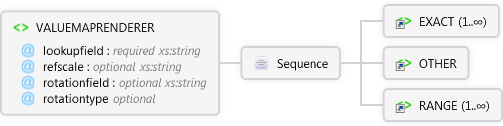
VALUEMAPRENDERER
Used to render features according to the value in a specified field. Based on this field, a value map can be created to classify data.
 |
lookupfield required xs:string
Name of field used to specify ranges for RANGE or exact values for EXACT.
|
|
refscale optional xs:string
Reference scale to display the TRUETYPEMARKERSYMBOL or SIMPLEMARKERSYMBOL at the specified fontsize using a relative scale such as 1:24000. TRUETYPEMARKERSYMBOLs and SIMPLEMARKERSYMBOLs are scaled relative to the refscale as the map is zoomed in or out.
|
|
rotationfield optional xs:string
The field in the table that contains the angle of rotation for a TRUETYPEMARKERSYMBOL.
|
|
rotationtype optional Restriction of xs:string
Three methods of calculating angles are available: 1)"arithmetic", An angle of 0 is east, and angles are calculated counterclockwise from east. 2)"counterclockwise", An angle of 0 is north, and angles are calculated counterclockwise from north. 3)"geographic", An angle of 0 is north, and angles are calculated clockwise from north.
|
 |
Sequence
 |
EXACT 1..∞
Used with VALUEMAPRENDERER for matching exact values within a specified field in the shapefile's DBF table. When a match occurs, the symbol is drawn as specified for that EXACT value.Used with VALUEMAPRENDERER for matching exact values within a specified field in the shapefile's DBF table. When a match occurs, the symbol is drawn as specified for that EXACT value.
|
|
OTHER
Used with VALUEMAPRENDERER as the default for rendering symbols that do not meet the criteria for any RANGE or EXACT values. Used with VALUEMAPRENDERER as the default for rendering symbols that do not meet the criteria for any RANGE or EXACT values.
|
|
RANGE 1..∞
Used with VALUEMAPRENDERER for matching a range of values within a specified field in a shapefile's DBF table. When a match occurs, the symbol is drawn as specified for each range.
|
|
|
Attributes
| Name | Type | Use | Default | Fixed | Description |
|---|
| lookupfield | xs:string | required | | | Name of field used to specify ranges for RANGE or exact values for EXACT. |
| refscale | xs:string | optional | | | Reference scale to display the TRUETYPEMARKERSYMBOL or SIMPLEMARKERSYMBOL at the specified fontsize using a relative scale such as 1:24000. TRUETYPEMARKERSYMBOLs and SIMPLEMARKERSYMBOLs are scaled relative to the refscale as the map is zoomed in or out. |
| rotationfield | xs:string | optional | | | The field in the table that contains the angle of rotation for a TRUETYPEMARKERSYMBOL. |
| rotationtype | Restriction of xs:string | optional | | | Three methods of calculating angles are available: 1)"arithmetic", An angle of 0 is east, and angles are calculated counterclockwise from east. 2)"counterclockwise", An angle of 0 is north, and angles are calculated counterclockwise from north. 3)"geographic", An angle of 0 is north, and angles are calculated clockwise from north. |
Examples
Restrictions
rotationfield, rotationtype, and refscale can only be used with TRUETYPEMARKERSYMBOLs.
Source
<xs:element name="VALUEMAPRENDERER" xmlns:xs="http://www.w3.org/2001/XMLSchema">
  <xs:annotation>
    <xs:documentation>Used to render features according to the value in a specified field. Based on this field, a value map can be created to classify data.</xs:documentation>
  </xs:annotation>
  <xs:complexType>
    <xs:sequence>
      <xs:element maxOccurs="unbounded" ref="apm:EXACT" />
      <xs:element ref="apm:OTHER" />
      <xs:element maxOccurs="unbounded" ref="apm:RANGE" />
    </xs:sequence>
    <xs:attribute name="lookupfield" use="required" type="xs:string">
      <xs:annotation>
        <xs:documentation>Name of field used to specify ranges for RANGE or exact values for EXACT.</xs:documentation>
      </xs:annotation>
    </xs:attribute>
    <xs:attribute name="refscale" type="xs:string">
      <xs:annotation>
        <xs:documentation>Reference scale to display the TRUETYPEMARKERSYMBOL or SIMPLEMARKERSYMBOL at the specified fontsize using a relative scale such as 1:24000. TRUETYPEMARKERSYMBOLs and SIMPLEMARKERSYMBOLs are scaled relative to the refscale as the map is zoomed in or out.</xs:documentation>
      </xs:annotation>
    </xs:attribute>
    <xs:attribute name="rotationfield" type="xs:string">
      <xs:annotation>
        <xs:documentation>The field in the table that contains the angle of rotation for a TRUETYPEMARKERSYMBOL.</xs:documentation>
      </xs:annotation>
    </xs:attribute>
    <xs:attribute name="rotationtype">
      <xs:annotation>
        <xs:documentation>Three methods of calculating angles are available: 1)"arithmetic", An angle of 0 is east, and angles are calculated counterclockwise from east. 2)"counterclockwise", An angle of 0 is north, and angles are calculated counterclockwise from north. 3)"geographic", An angle of 0 is north, and angles are calculated clockwise from north.</xs:documentation>
      </xs:annotation>
      <xs:simpleType>
        <xs:restriction base="xs:string">
          <xs:enumeration value="arithmetic" />
          <xs:enumeration value="counterclockwise" />
          <xs:enumeration value="geographic" />
        </xs:restriction>
      </xs:simpleType>
    </xs:attribute>
  </xs:complexType>
</xs:element> |
See Also