Description
Used to specify the GPS tracklog settings in ArcPadPrefs.apx.
Diagram
Overview
 |
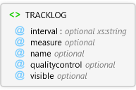
TRACKLOG
Used to specify the GPS tracklog settings in ArcPadPrefs.apx.
 |
interval optional xs:string
Interval of GPS fixes to capture at in the tracklog shapefile.
|
|
measure optional Restriction of xs:int
The GPS measurement that is stored as the tracklog shapefile's measure value (M-value). The values that represent each measurement are: 0 = PDOP 1 = HDOP 2 = VDOP 3 = TDOP 4 = EPE 5 = HPE 6 = VPE 7 = TIME 8 = DEPTH 9 = SOG 10 = QUALITY
|
|
name optional
Complete path and filename of tracklog shapefile.
|
|
qualitycontrol optional Restriction of xs:string
Flag that determines whether quality control parameters are used to filter out GPS fixes captured in the tracklog shapefile.
|
|
visible optional
Specifies whether the tracklog is displayed.
|
|
Attributes
| Name | Type | Use | Default | Fixed | Description |
|---|
| interval | xs:string | optional | 1,0,0 | | Interval of GPS fixes to capture at in the tracklog shapefile. |
| measure | Restriction of xs:int | optional | 0 | | The GPS measurement that is stored as the tracklog shapefile's measure value (M-value). The values that represent each measurement are: 0 = PDOP 1 = HDOP 2 = VDOP 3 = TDOP 4 = EPE 5 = HPE 6 = VPE 7 = TIME 8 = DEPTH 9 = SOG 10 = QUALITY |
| name | | optional | | | Complete path and filename of tracklog shapefile. |
| qualitycontrol | Restriction of xs:string | optional | true | | Flag that determines whether quality control parameters are used to filter out GPS fixes captured in the tracklog shapefile. |
| visible | | optional | false | | Specifies whether the tracklog is displayed. |
Examples
Source
<xs:element name="TRACKLOG" xmlns:xs="http://www.w3.org/2001/XMLSchema">
  <xs:annotation>
    <xs:documentation>Used to specify the GPS tracklog settings in ArcPadPrefs.apx.</xs:documentation>
  </xs:annotation>
  <xs:complexType>
    <xs:attribute default="1,0,0" name="interval" type="xs:string">
      <xs:annotation>
        <xs:documentation>Interval of GPS fixes to capture at in the tracklog shapefile.</xs:documentation>
      </xs:annotation>
    </xs:attribute>
    <xs:attribute default="0" name="measure">
      <xs:annotation>
        <xs:documentation>The GPS measurement that is stored as the tracklog shapefile's measure value (M-value). The values that represent each measurement are:
0 = PDOP
1 = HDOP
2 = VDOP
3 = TDOP
4 = EPE
5 = HPE
6 = VPE
7 = TIME
8 = DEPTH
9 = SOG
10 = QUALITY</xs:documentation>
      </xs:annotation>
      <xs:simpleType>
        <xs:restriction base="xs:int">
          <xs:minInclusive value="0" />
          <xs:maxInclusive value="10" />
        </xs:restriction>
      </xs:simpleType>
    </xs:attribute>
    <xs:attribute name="name">
      <xs:annotation>
        <xs:documentation>Complete path and filename of tracklog shapefile.</xs:documentation>
      </xs:annotation>
    </xs:attribute>
    <xs:attribute default="true" name="qualitycontrol">
      <xs:annotation>
        <xs:documentation>Flag that determines whether quality control parameters are used to filter out GPS fixes captured in the tracklog shapefile.</xs:documentation>
      </xs:annotation>
      <xs:simpleType>
        <xs:restriction base="xs:string">
          <xs:enumeration value="true" />
          <xs:enumeration value="false" />
        </xs:restriction>
      </xs:simpleType>
    </xs:attribute>
    <xs:attribute default="false" name="visible">
      <xs:annotation>
        <xs:documentation>Specifies whether the tracklog is displayed.</xs:documentation>
      </xs:annotation>
    </xs:attribute>
  </xs:complexType>
</xs:element> |
See Also